Interstate 90 starts in Seattle and buries itself deep into the Snoqualmie valley, climbing with its south fork before crossing a low divide, hooking to the south and following the Yakima River. So the South Fork of the Snoqualmie, despite being rugged country, is easily-accessed and well-traveled. But the Snoqualmie's other tributary, the Middle Fork, is an
enigma. Although is just as close as the crow flies to urban Seattle, and despite having a "road" along its bank for quite a ways of its length, it is as lightly-trodden as it is rugged. The "road" has gone from being unmaintained and halfway-abandoned to the automatic-weapons aficionados to outright closed in recent years. This adds a 13-mile road hike or bike to the itinerary if one wants to access the Middle Fork.
Yet the South Fork is just over the divide from the Middle Fork, which got me to thinking about how I might be able to hop the divide and save myself a bit of hiking. A thorough review of the maps showed that the Cooper Creek Road, off I-90 and outside Cle Elum got you within striking distance to the east side of Overcoat. So Chris A. and I gave that a try.
We set off at 6AM in sneakers from the Cooper Lake TH. We hit patches of snow almost immediately, but nothing long enough to bother putting on the skis and boots. In any case, the trail to Pete Lake is cursed with gaining only 300 feet in 5 miles, so even with continuous snow, snow is a dubious advantage.
We hit Pete Lake at 8:15. This was taking longer than I thought. At least now we were on the map, though. Another 3 hours of following the trail as it joined the PCT, then leaving the trail as it began switchbacking its way east and following the bank of the tributary creek of the Cooper for a half mile through big timber, then open slopes finally got us to where it was clear we had snow for the rest of the way up.
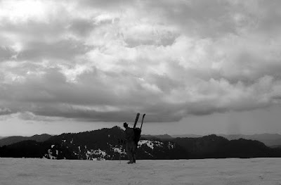
Pete Lake in the morning

Basin below the Summit Chief-Chimney Divide hammered by avalanche

We skinned through piles of avalanche debris full of rocks and trees, all the while looking back to the south at the ominous clouds building. The key to getting to the Chimney-Overcoat Col from the Cooper drainage were two broad couloirs that provide a gentle way through otherwise cliffy terrain. I was worried even these could be melted out to slab by all the heat we were getting. Luckily my worries proved to be unfounded. We made it to the head of the valley, and turned nearly 180 degrees southwest and ascended the first couloir/ramp. 500 feet of skinning took us to the unnamed glacier below the east face of Chimney. We turned 90 degrees north and found the next ramp. It had some waterfalls and cliff bands showing on its east side, and looked steeper. This being Chris's first time on skins, it seemed wise to switch to boots for more security, and to take a more direct line away from Chimney's face, which had dropped some rocks onto the snowfield.
One thousand feet later we had arrived on the Overcoat Glacier. It was already 2 PM, but fortunately the thunderheads to the south had retreated. After taking another break to admire the scenery, we skinned our way across the broad plateau, almost an icecap, and went around the corner to Overcoat's north side. The couloir was fat. We kicked steps up to a wide col at the top of the couloir, which lay between rocky battlements of the summit ridge. My altimeter was claiming we needed another 300 feet for the summit of Overcoat, but I didn't want to to believe it and scrambled a little ways up a promising-looking tower, until I finally caught a view of the true summit of Overcoat. It towered several hundred feet above me and looked decidedly fifth class from that side. So I deemed the skier's summit "good enough." It had a cool window you could scramble through and catch a view to the south, anyway.
Booting up the second ramp

Panorama of Chimney from the Overcoat icecap

View from Overcoat's col. Wish we could have made a camp here.

Chris skiing the apron below Overcoat

The top of the run was the steepest, but the snow was good, albeit a little overcooked. They seemed like some of the steeper turns I've linked in a while. Chris did an excellent job for not having skied for the past two years.
The rest of the run was all downhill from there, however. Even at 6600 feet, over 1000 feet above treeline, the snow was fouled with pollen. We skated our way downhill across the glacier, only to endure a 2000 foot run of sticky, grabby snow. I was able to straightline 20-25 degree slopes and hardly exceed a running pace. This transitioned into rock-strewn avalanche debris lower down, which actually skied faster than the rest of the tar, since the chunks meant less snow contacted the ski.
We changed back to boots at 6PM and prepared for the long hike out. We made it back to Pete Lake around 8, and I was still feeling pretty good. However, by the time sunset rolled around, I was starting to bonk. We arrived at the car at 11, hallucinating a little by headlamp: snakes in the bushes, snakes in the trees.
Pollen sticks