Sunday, May 15, 2011

Escape from Provence

Without a plan besides seeing more Provençal cities that were supposedly neat, we headed west out of Orange. We quickly felt the pull of the Rhone as the land flattened and the traffic turned more industrial. We crossed a bridge, a long, slender island between channels, and some locks and were suddenly west of the Rhone.

Some wrong turns and some kilometers later, we arrived at the city of Uzes, an obviously European city, since the entire, plus-beaux village is one giant roundabout. We were under-inspired. However, that night an rogue wifi connection in the camping showed that we could bid adieu to Provence and keep heading west into a Parc National. On the far side of Parc National Cevennes was Millau, a town with a train station that looked a couple of days of riding away. On the map were lots of green-underlined small roads, which mean scenic and untrafficked. Which is normally a good bet.


I < 3 poppies

The next morning, despite our best efforts in Orange and Uzes, we were still out of stove fuel, and therefore, coffee. We headed back into town for caffeine so that our brains would function. We held council over a map and cafe. The synchronicity of the prior night continued. As it came to pass, beside us was a Frenchman who lived in Uzes and built bikes and when he saw that we were avec velo and pondering a map, he offered to advise us on a route. We left with several circles scribbled on our map, and feeling a little pleased, since our gibberfrench seemed more intelligible than normal.


Heading into the hills


Roadside attractions


The going was going to be good.

Saturday, May 14, 2011

Polar opposites

Gravity dropped us in Malaucene mid-afternoon on a Saturday, a bizarrely disagreeable town. Its centreville featured a boulevarded parking lot, choked with traffic trying to enter. Calvacades of motorcycles, RVs and the occasional tractor (driven by, no lie, a leering frenchman wearing a beret and flying a tricolor) rumbled through the streets. We fled for the outskirts of town, and found a campground, which at first glance appeared delightful. The camping, Le Bosquette, is on an orchard perched above town. It has a swimming pool. It has spotless bathrooms. Great.


Grapes all over the place

Oh, I forgot to mention that the orchard was subsequently covered in a uniform layer of sharp gravel, with nary a patch of grass for the beleagured tent camper to patch her/his tent; tractors are roaring from dawn-dusk in the field below in some sort of exhibition; the swimming pool is just a dry pit; and the toilets, while clean enough for the Virgin Mary to eat out of, have neither seats nor TP. So yes, bizarrely disagreeable.


Highlight of Malaucene centreville

We got as quick of a start as we could manage the following morning, feeling sapped and slightly demented from the angry rays of the sun that hit our camp as soon as it had risen. The tractors, too, had already began their combative droning, while vaguely militaristic symphony music echoed up to Le Bosquette. We had hatched a plan to shorten our day to Orange by taking a little penalty climb at the start, then cutting through the Dentelles de Montmirail, a range of limestone teeth that formed in the wake of the orogeny that lifted Ventoux.


Dentelles from a Col

We crossed the ridge and our outlooked improved immediately as we caught a minor breeze and left the tractors behind. The penalty climb was quickly dispatched and we began a 10k descent on banked roads with clean, smooth asphalt and kickass views that dropped us on the edge of the Rhone's alluvial plain. Some more quiet, smooth roads led to a narrow, more trafficked road that we conquered with our new technique of the flying wedge. (In which Erin takes shotgun and rides near the fogline. Andrew rides a bikelength in front, and rides far enough into the lane to force a lane change in passing cars. Cars can tell how many bikes they are going to pass, and both Andrew and Erin can see approaching cars in their mirrors. It also works well in roundabouts, which while are great traffic engineering for cars, hover between frightening and unnavigable on bikes, depending on diameter and traffic volume.)


Looking back at Ventoux and the Dentelles

We quickly arrived in Orange, a dusty, medium-sized city with some Roman ruins 'n' stuff and a poorly signed, but very helpful tourist office. We stayed there for a bit and ate pizzas and nutella.


We carried this pizza about 50 km from Malaucene in 80 degree sun. It miraculously didn't make us poop our pants when we ate it.

Wednesday, May 11, 2011

Le Mt Ventoux

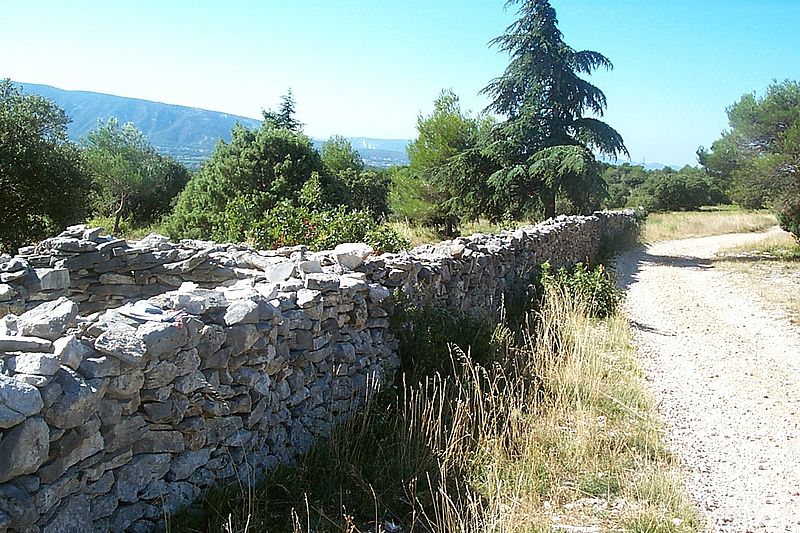
200m: Leave from Jouncas, head up the valley towards and past Murs Coll, past the wall that gives Mur it's name. The wall extends the length of the Provencal countryside. It was erected from dry stone by citizens after a governmental decree in reaction to the bubonic plague overwhelming the streets of Marsailles. It was coined the mur de la peste and was guarded along its length 24 hours a day by sentinels. To be able to cross, one must have a clean bill of health in hand. A lasting representation of panic surrounding the outbreak.


(Picture egregiously stolen from wikipedia)

900 m: Views of Mt Ventoux begin to show in the distance as we reach the peak of our climb for the day and head down to Sault.


810 m: We stop for eau potable and watch goats cross the road at a busy rural intersection.


740 m: The road switchbacks up 100 meters and dumps us into Sault, perched airily above the valley. Feels like finishing a Tour de France stage. We enjoy beers and look out at the valley as the sun sets.


680 m: We drop to the valley floor before starting our climb to the top of Ventoux. The road is gently graded and in the trees at first. Scattered Tour graffiti spray painted on the road makes for interesting reading as we climb.

1440 m: We triumphantly emerge above tree line. After a picnic break we begin the exposed climb over white, tumbling talus, which gives the mountain its snow-covered appearance from far away. The climb steepens to over 10% grade and the temperature begins to drop slightly as the wind picks up. I am passed seven times on the way to the summit by others in race kit. He who finishes last still finishes, right?  Andrew passes one man dressed in head to toe spandex and on an ultralight bike...and then won't quit talking about how he now owns this man's soul forever.


1850 m: Only one kilometer to go, the observatory on top of the mountain gets closer in view.


1912 m: Summit time! Excited to be done with the climb, and feeling self-accomplished for completing an HC climb with full touring gear. Battered by the wind, we do not stay long to revel in our accomplishment.


1700 m: Rim-boiling steep, airy descent with amazing views to the north.


440 m: We arrive at Maulacene, among many old men playing bocce ball, a strange beauty pageant, and a noisy tractor demonstration. We work on consuming as many calories as we burnt during the day in pizza and salad.

Sunday, May 8, 2011

über lüber

Crruunnchh, smack, smack, smack. The sound of a small animal chowing down next to my left ear abruptly woke me from sleep at the municipal campground in Apt. I sat upright, shook Andrew awake. "Wake up, there's a huge rat in our tent trying to eat my ears! Where's your headlamp?"

While he searched, the animal seemed to lunge at the border of the Megamid and I tried to stop it's vicious approaches with my water bottle. But, I struck something more substantial than a soft animal, and the figure just rolled on it's side slightly.

"It's a huge porcupine!"

Actually, with a little light, it proved to be a very petite hedgehog in the middle of a midnight snack of snails. Feeling a bit foolish, but still not ready to go back to sleep with a hedgehog for a pillow (the downside of having a bottomless tent-tarp), we left the tent for a few minutes and watched the little guy scurry away. Apparently he wanted nothing to do with an over-dramatic sleep-deprived Americane.


hedgehog, frightened into a ball

The riding from Forcalquier to Apt had been uneventful, filled with fields of grapes, olives, and silage. We had followed the zig-zagging Luberon bike route against a fierce headwind the first day, and soon departed from the bike route after leaving Apt on the second day due to bumpy roads and unnecessary climbs. We opted for smoother sailing and more direct routes to the few villages in the Luberon that we had decided to visit that day.


fun descent into Reillanne

Bonnieux was our first stop, and what you would expect from a quintessential Provençal ville: beautiful, green, filled with tourists, and surrounded by ruins. We spent time wandering the ruined church lookout, taking pictures, and unintentionally feeding the ants a healthy picnic.


crazy cobblestone


stairs up


rooftops over Bonnieux

We sped down, up, down, up to the next venue of the day: Roussillon. France has a ranking system for the most beautiful villages, or "Les Plus Beaux Villages de France". To be added to the list you must pass several tests of quality, beauty and support. We had already passed through a few of these villages without knowing they had undergone this stringent selection process, but Roussillon let you know as soon as you entered. It had plaques and signs lit by Christmas lights galore touting its fame in the list. Built upon ocher cliffs and surrounded by seas of red and green, it probably deserved its self-congratulations.


exploring the ocher cliffs


the extra creepy blue-eyed keeper of o the Ocres


Roussillon in all of its splendor


red dust-covered shoes

We wandered away from Roussillon with threatening thunderclouds overhead late in the afternoon. After not much more pedaling, we decided to stay the night in Joucas to cut down on our 900 m climb the next day to Sault, the jumping off point of Mt Ventoux.