 |
| Crossing Bridge of the Gods |
Bridge of the Gods to White Pass
Last year, after finishing an 8 day trip on the Washington PCT between Stevens Pass and Stehekin, Andrew and I decided to make it a goal this summer to section hike Washington on the PCT. We found the time, bought, packaged and sent meals, and weighed gear in anticipation. Then we set off the last week of July toward the Oregon-Washington border.
We hurriedly ripped out the first chapter of the "Pacific Crest Trail: Oregon and Washington" guide book on the way out the door of our apartment. I began reading it in the backseat on the ride down to Cascade Locks a few hours later. The author's thoughts on the first 40 miles of the Washington PCT were not painting a pretty picture. There were recommendations to road walk or skip the first 37 miles, where it is hot, there are no views, and a section where you descriptively could "fall to certain death". I put the book aside, deciding this was not the way I wanted to think about our start.
 |
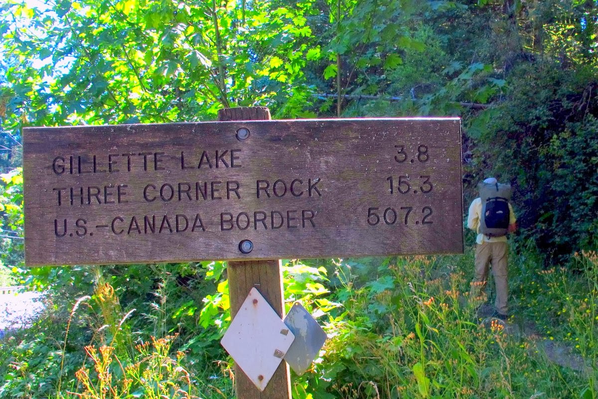
| 507.2 miles to go |
After a lunch with Andrew's family, we started the ceremonial walk across Bridge of the Gods among the slowly-buzzing traffic and crosswinds. Our 500-mile walk to the Canadian border had started. We didn't notice that the trail was hot nor dry nor ugly, and we most certainly didn't fall to our deaths. We would only use the guidebook, or as we now call it, "The Book of Lies", for facts - campsites, water sources, that sort of thing. Feelings about a trail vary greatly from experience to experience - maybe this author had experienced something unpleasant (bees? days of rain? thick mosquito clouds? a pooping misadventure? a scary fall? an existential crisis?) on the southern Washington section, while we were just happy to be out of the city and walking North.
 |
| Show-off succulents. |
 |
| Columbine. |
The first 37 miles to Panther creek meandered more in the east-to-west direction than we anticipated, and we kept getting glimpses back to our starting point back at the Columbia river. Each time we hoped it would look further away, but mostly it just looked the same size when we would bust briefly out of the trees.
 |
| The Mighty Mother Columbia |
 |
| Rewarded with only brief glimpses of what seemed like faraway peaks - Mt Hood in this one. |
 |
| Treed walking. |
We entered Mt Adams Wilderness in short order and, man, was it wildflower season! There were crazy bursts of color in every direction. There were even pops of color through the ashes and snags of last year's wildfire.
After about 20 miles of wildflowers and beautiful mountain views, the trail again dipped down into the valley and back into the trees. We spent a day curving around Yakama tribal lands, crossing large lava flows (one with amazing tasting spring water spouting from the rock), and climbing the vegetated hillsides above Walupt Lake - now officially in the Goat Rocks Wilderness.
We had heard how amazing the Goat Rocks were, but we were blown away the next day when we crossed through this staggering section. There were verdant basins, jagged peaks, and a mind-bending knife-edge ridge trail - who could ask for more?
 |
| Peaks of the Goat Rocks in one of the basins |
 |
| Crossing Cispus Pass |
 |
| Another goddamn beautiful basin |
 |
There were several low-angle snowfields to cross as we headed up towards Old Snowy.
|
 |
| Views of Rainier in the Cloudy Distance from atop Old Snowy |
There are a couple of route options when crossing the Goat Rocks. You can climb up to the top of Old Snowy Mountain (the old PCT route), or cross lower down over a glacier (new PCT route). We took a look at both routes, listened to advice from south-bounders, and decided we would choose the route that added a bit of elevation but avoided the sketchy-looking snow field (the old PCT route). The lower route might look more appealing as it melts out later in the season, but we were sans ice axes and the consequences from a fall without a way to self-arrest looked like they should be avoided.
 |
| A group of elk gathering on a snow field - from up here they just looked like rocks |
 |
| Mt Rainier, looking like a ghost in the distance. |
We picked our way over lose rock to the top of Old Snowy, where we got glimpses of Rainier in the ever-gathering clouds. Flashes in the distance made us decide that hurrying down of this exposed section would be in our best interest before the lightening closed in on us. Soon enough we found that "hurrying" doesn't work very well on this part of the trail. It took us about 4 hours to cover 5 miles.
I kept thinking a few things as we picked our way over the knife-edge trail:
1.) Holy shit, I will die if I fall.
 |
| Loose-rock descent from Old Snowy |
2.) Look at these crazy flowers. There are so many diverse types of vegetation surviving in these exposed, harsh conditions.
3.) What are these bees thinking? They have to constantly fight the winds to pollinate these flowers. Makes me tired just watching them.
4.) Erin, stop looking down. You're freaking yourself out.
5.) Who was the crazy person who looked at this section and decided, "Hey, I think we should make the trail follow the ridge for 5 miles - like a mini sidewalk through the sky. I'll go get the dynamite." Definitely signs of a different era of trail design.
 |
| From the top of Old Snowy |
 |
| One of the not-so-steep sections of trail. You can see the trail following the ridge in the distance. |
 |
| Inadvertently hugging the wall |
 |
| The Goat Rocks |
 |
| Crazy rock |
 |
| Flower arrangement on the side of the ridge trail |
 |
More flowers
We got off the ridge right in time as the cold rain and mist crowded in over the ridge. We pitched the tarp, had a nap, and ate some ramen while the worst of the storm passed overhead. Everyone else had the same idea and campsites got crowded fast in the basin. After waiting out some of the rain and deciding that spending the night crowded in on a small flat spot with 8 boy scouts might not be the most serene way to spend an evening (even though they were very polite and enthusiastic), we decided to walk down further to a drier, wooded area to camp.
We promptly made dinner and slept hard, waking up to clearing skies and a few more dramatic vistas on the way down to White Pass. |
 |
| Looking back at where we crossed the Goat Rocks |
Feeling a bit beat up, we decided to take a rest day at White Pass, eating fried chicken and eggs and taking showers while the weather passed (we hoped). We took walks, stretched, slept, and watched whatever random DVDs were left in the hotel room by the last inhabitants.
Then, this crazy thing happened:
When taking a walk we heard a voice from the bushes at the side of the road that sounded like a child's toy...."this little piggy went to market, this little piggy stayed home...". Thinking it must have been accidentally lost from a car, Andrew sauntered over to the bushes to take a look. He pulled out what appeared to be a walkie-talkie with many severed wires erratically sticking out from the sides of the box. While it looked like something you would definitely report as suspicious in the city, we didn't know what to make of it out here. He laid it back down gently and we backed away from it slowly.
The next day we crossed the same area and the device was still sitting on the ground. It was no longer spouting nursery rhymes, so I figured the batteries had just run out of juice. I poked at it with my trekking pole. It just laughed maniacally at me. You know those time when you do things that you later realize might not have been the right thing to do? This was one of those times. I ran away, making a weird laugh-cry noise.
Andrew prodded it a second time as he walked by. It responded with a husky "Paddy-cake, paddy-cake". You know those times when you do something you probably shouldn't do a second time? This was one of those times. We were both a little creeped out and walking fast in the opposite direction - away from the frightening machine.
I had some nightmares that involved a clown saying paddy-cake, paddy-cake over the next few nights, and I still wonder what kind of device it was. A practical joke with someone on the other end of the walkie talkie? A speaker from a kid's toy that was ripped out and tossed out of a vehicle window because it was driving a parent crazy? I guess I'll never know, but I will continue to keep this story in my creepy story repertoire.
White Pass to Snoqualmie Pass
Not gonna lie, I was not expecting much from the White Pass to Snoqualmie section of trail other than clear cuts and tree walking. And, yes, a lot of this section was logged and not glamorous. There were also surprisingly pleasant and scenic areas - most notably around Chinook pass.
Andrew was impressed with how well-constructed the trail around Chinook was, and it truly hit those notches in the passes perfectly, without superfluous elevation changes. I enjoyed the fact that we stayed high with views in all directions for the larger part of the first days.
 |
| Near Bear Gap |
 |
| A cloud show at sunset |
 |
| Views of Rainier around Crystal Mountain |
As we headed north, the land started showing off it's scars. Previous logging and fires were evident between forest service road crossings for the next 70 miles. This section was also hot this time of year - partially due to less old growth to keep the sun at bay, but mostly because temperatures were in the high 90s. Our blisters grew as our feet would swell and our shoes fit more snugly.
 |
| Tree graveyards |
 |
| Old PCT sign. |
 |
| Huckleberry bush growing in the middle of a logged tree trunk |
We did get to enjoy some encounters with elk and marmots. We woke up several times at night to bugling. These sounds are otherworldly nasal cries used for courtship (to put it nicely) and/or domination. The most notable place we heard elk was at the Urich cabin around Government meadows. The elk came out to practice their calls in the early-morning hours as the mist hung low to the field, and I laid awake getting goosebumps every time they would bellow.
 |
| Marmots like to eat Lupine - I never knew. I thought they only liked eating my sweaty/salty pack straps. |
We caught an easy ride from east of Snoqualmie pass back down to Seattle. We were dropped off in the middle of the city near the courthouse, where there were tens of fire trucks, emergency personnel, hazmat vehicles, reporters, streets of gawkers, and yellow tape. We waited for the bus, dazed by the spectacle of the city with that special brand of wide-eyed confusion of someone that has not been in civilization for awhile.


Stumbled across your blog while searching for information about section hiking the WA PCT. Looks like a great trip and enjoyed your photos!
ReplyDeleteThanks Joan! The section from Snoqualmie north is amazing, and I think that the Stevens to Stehekin section rivals the JMT (both totally different, but equally beautiful).
DeleteLooks like you hail from close to my home. I grew up in North Georgia. A lot of the hikes on your blog make me think of home:) If you have specific questions or need a contact in Seattle when you come up to section hike let me know - my email address is grinerin@gmail.com.